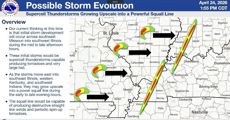
The National Weather Service in Paducah says western Kentucky could face a potentially significant severe weather event on Monday, with forecasters growing increasingly concerned about the possibility of all modes of severe weather from late afternoon through the evening.
During a Friday weather briefing, lead meteorologist Derrick Snyder said the latest outlook from the Storm Prediction Center places much of the region under at least some level of severe weather risk for Monday, with the current forecast highlighting an enhanced risk generally from around the Evansville-to-Murray corridor and a slight risk farther east, to include Madisonville and Hopkinsville toward Bowling Green.
Snyder cautioned that the exact placement of those risk areas is still likely to shift as newer data comes in over the next couple of days.
click to download audioEven with some uncertainty remaining, Snyder says the main timing window appears to be late afternoon through around midnight, with a rough early estimate of 3 p.m. to midnight, though that could still shift by several hours.
Snyder also says the environment could support tornadoes, including the potential for strong tornadoes, along with destructive straight-line winds of 70 to 80 miles per hour and very large hail of two inches in diameter or greater.
He adds that the initial storms may form as supercells, which are often associated with the strongest tornadoes and the largest hail. Later in the evening, those storms could evolve into a squall line, shifting the primary concern toward damaging winds and rapidly spinning-up tornadoes, especially as storms move into western Kentucky after dark.
Snyder says the forecast models have remained remarkably consistent for several days, something forecasters often see with more significant severe weather setups.
click to download audioSnyder says the forecast is still several days out, meaning important details remain uncertain, such as the exact timing, storm mode, and location of the greatest risk.
Your Weather Edge will keep you posted and provide live coverage on our stations when needed.